Origin and Foundation
The name "Samaná" comes from the region's original indigenous name. During the conquest and colonization, it was written as "Xamaná."
The province was one of the first territorial divisions of the Dominican Republic, created in 1865 as a "Maritime District." Later, in 1907, it officially became a province after the elimination of that category.
Visit by Columbus and European Colonization
- 1493: Christopher Columbus visited the territory during his first voyage, marking the first hostile encounter between Europeans and the Ciguayo people.
- 16th-17th Centuries: The region remained almost uninhabited, frequented by escaped slaves, European settlers, buccaneers, and privateers.
- 1756: The town of Santa Bárbara de Samaná was founded with families from the Canary Islands.
Territorial Evolution
- During the Haitian occupation (1822-1844), Samaná received Haitian migrants and former North American slaves.
- In 1958, the María Trinidad Sánchez province was created, significantly reducing Samaná's territory.

Current Municipalities
- Santa Bárbara de Samaná (includes Arroyo Barril, El Limón, and Las Galeras as municipal districts).
- Las Terrenas.
- Sánchez.
Geography and Climate
Natural Regions
- Samaná Peninsula: Dominated by the Sierra de Samaná.
- Highest mountain: La Meseta or Monte Mesa (605 m).
- Wetlands: Gran Estero and Bajo Río Yuna.
Hydrology
- Main Rivers: Limón (14.5 km), San Juan (12 km), and Majagua (6 km).
- Wetland Area: Bajo Río Yuna, with significant rivers such as the Yuna.
Weather
- Tropical rainforest climate with rainfall throughout the year.
- Precipitation:
- Samaná: 2,349.8 mm annually.
- Sánchez: 2,062.7 mm annually.
- Average temperature:
- Samaná: 26.5 °C.
- Sánchez: 27.1 °C.
Economy
Main Activities
- Tourism: Prominent in Samaná, Las Terrenas, and Las Galeras, including whale watching.
- Agriculture: Coconut and taro cultivation.
- Fishing and Mining: Small-scale marble production.
Demographics and Evolution
- Population Density (2010): 119.8 inhabitants/km².
- Urban Population Percentage: 43.5%.
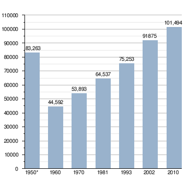
- Historical Population Evolution:
- 1950: 83,263 inhabitants (includes the current María Trinidad Sánchez province).
- 2010: 101,494 inhabitants (1.07% of the national population).

Location and Establishment
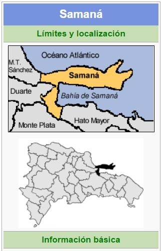
- Location: Northeastern Dominican Republic.
- Establishment: Founded in 1867.
General Information
- Capital: Santa Bárbara de Samaná.
- Population: 33,196 inhabitants.
- Area:
- Total: 862.8 km².
- Percentage of national territory: 1.8% (25th place).
- Altitude:
- Highest point: 605 m.
- Lowest point: Sea level.
Neighboring Provinces
Hato Mayor, Monte Plata, Duarte, y María Trinidad Sánchez.
Total Population (2010)
- Number of inhabitants: 101,494 (22nd place).
- Percentage of the country: 1.1%.
- Population density: 120 inhabitants/km².
ISO Code and Administrative Region
- ISO Code: 3166-2:DO-20.
- Administrative Region: Cibao Nordeste (Region III).
Samaná is a province rich in history, biodiversity, and culture, representing an important tourist destination and a natural treasure in northeastern Dominican Republic.
Source: Dominican republic goverment


